
Maps, maps, maps
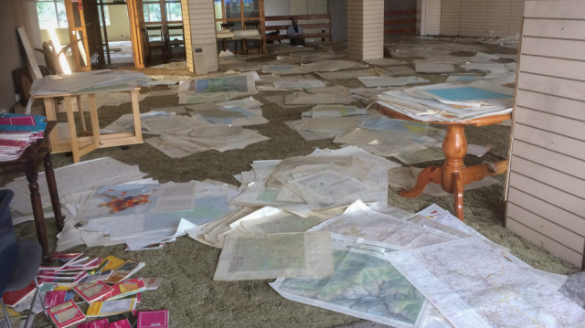
Yesterday I saw a tweet about it, and then spoke about it with the couple in the cafe in Dunbar, so today I went along to the Zero Waste shop in Musselburgh to have a look at the old maps. Downstairs there was a small bundle of maps in a basket - surely they could have sold thousands in a few days? There didn't seem to be any more and then, towards the back of the shop, I found a set of stairs and a sign pointing to maps upstairs. And this was the scene that greeted me. Piles and piles of maps scattered across the floor. The maps are a portion of the 25,000 maps that the Edinburgh University Geography Department got rid of recently. Rather than send them to landfill, they were intercepted by the Zero Waste group and put on sale. Apparently they have only 'released' a bit more than half of them so far so it might be worth going back in a couple of weeks. Anyway, I spent an enjoyable couple off hours looking through the maps. Found one of Dundee that must have been printed before the 1960s, as the estate I grew up on isn't on it. And there were lots of maps of central and eastern Europe from the second world war period - German ones of occupied Poland and British military ones. Interesting to move to another bundle of maps and discover somewhere else I was familiar with - Malta, Brittany, Czechoslovakia and many more. I slowly accumulated a pile of more than twenty maps, which I managed to half in number before going to the till.
The (OCD?) organiser in me found it difficult that there was no organisation in evidence - not even a system by which the maps could be gradually sorted as people look through them. If it was me, I'd set aside some areas on the floor (possible marked out with masking tape) for different areas across the world. And a sketch map of the room to show where they all are. Some continents, with lots of maps, would be subdivided into countries, while others, at least until the number of maps mounted up, would remain at the continental level. Each, initially empty, square with a label, such as 'Scotland', 'Germany' or 'Africa', would have another square alongside it marked as 'Not Scotland', 'Not Germany' and 'Not Africa'. And beside the pairs of empty squares there would be an unsorted pile of maps. The first person to go through the pile - probably because they had a specific interest in that area - would divide maps between those that match the category and the rest Having been through a number of maps you'd get a sense of where the majority of the 'rejected' maps should go and that 'Not-' pile would be transferred to the unsorted pile in front of that square for the next person interested in that area to sort.
Oh, and I forgot to add - saw two Kingfishers flying up the Esk as I sat down to have my lunch after looking through the maps!
Comments
Sign in or get an account to comment.


