
The Northern Threat
The picture above is a photograph of part of a website screen belonging to Geoscience Australia, a department of the Australian Government. It is called DEA Hotspots (i.e. Digital Earth Australia Hotspots)
https://hotspots.dea.ga.gov.au/
PLEASE SEE LARGE. It is not a picture from a television screen. I feel encouraged to publish this because the overarching copyright message on the site runs as follows:
(c) Commonwealth of Australia (Geoscience Australia 2019)
Geoscience Australia supports and encourages the dissemination and exchange of information provided on this website.
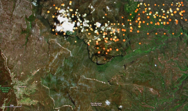
This portion of the screen shows the relative positions of the "Mt Gospers" fire (currently burning along the northern extremity of the Blue Mountains National Park viz the Grose Valley) and our town of Blackheath. The hotspots you see are not necessarily to the scale of the map but they DO indicate the direction in which the fire may be travelling. Each spot is plotted by satellite passes over the region. The dark red spots are the most recently plotted while orange and yellow spots are progressively older. This tends to suggest that the blaze is presently headed south east and not directly toward our town.
This is perhaps a self centred view because the fire ultimately seems headed to the major town of Springwood, which is also a highly undesirable target. If you go to the DEA Hotspots website you can cruise about and find out where all the fires really are. For those of you with friends or relatives near fires, the website gives the best purely graphical information I have thus far found, regarding ALL the fires. I thought you should all have access to the information.
263
views
- 25
- 0
- Olympus E-M5
- 1/50
- f/4.5
- 22mm
- 800
Comments
Sign in or get an account to comment.


