
Clifton Wells?
So. It’s the last Sunday in May and the last day of the Penrith shaking bottle ceremonies which started here ... https://www.blipfoto.com/entry/2703715369641578060
Traditionally the last Sunday was the turn of Dicky Bank holy well https://www.blipfoto.com/entry/2667849127311705517
I had no great wish to go back there again today. Instead, during a sleepless night I had got absorbed by Michael Gray’s well which had led me on a meandering route and a dispute between the Duke of Portland (in the Penrith corner) and Sir Philip Musgrave, Bart. (In the Edenhall corner). To settle the disputed lands boundary stones were laid, one of which was placed at Michael Gray’s well. I searched and searched but couldn’t find any sign of it on a map nor any other reference to it and have absolutely no idea who Michael Gray was either. However, there is mention that it was another shaking bottle well. As I continued to pour over the map I was intrigued to discover a stream called Liquorice Sike near Edenhall.
After more painting and general odd jobs listening to Adam Rutherford talking about his book, ‘How to argue with a rascist’, I set off to have a look. I couldn’t find much sign of the Sike, nor a boundary stone, I had forgotten my camera and there were runners and cyclists and dog walkers and I was very quickly not in the mood for it so I headed straight back home. I think I’m going to find reintegration quite hard when the time comes.
I then decided to get on my bike and see if I could find Clifton wells instead. And here we have yet another confounding well mystery. The Clifton shaking bottle well is St.Cuthbert’s, or Kelter, Well https://www.blipfoto.com/entry/2147746654936105914
However, on the map, by the Lowther river there is also ‘Clifton wells’ marked and these have also been used historically...
‘Dr. Todd mentions a fountain in this parish near the banks of the Lowther of christalline limpid water, strongly impregnated with steel, and vitriol, of great benefit for scorbutic complaints.’
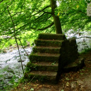
Anyway, the path is on the opposite side of the river but I had a good rummage to and fro in the right area and reckon this is probably it. It is in the right spot and no other reason why there would be railings in such a spot otherwise. What was really interesting though was there were signs of an old walkway and remnants of a bridge over the river (extra) and I can’t find any reference to this anywhere. So, more mysteries wrapped in enigmas.
Sorry freespiral ... probably not very holy, although I’m blowed if I can work any of it out.
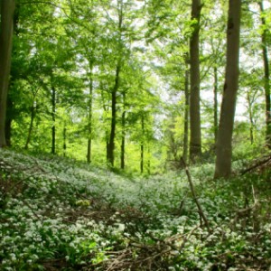
As if that wasn’t enough excitement, I went on to look for Castlesteads, an Iron Age fort in the woods further along, above the river. Heavily wooded now but you can still make out the ramparts (extra).
Note: I’ve just read that Thomas Wilkinson (of Wordsworth’s Thomas Wilkinson’s spade fame) laid out paths along the Lowther in 1804.
Comments
Sign in or get an account to comment.


