
Flooding
The modern Saint-Malo is built mostly on reclaimed land between the ancient towns of Saint-Servan, Paramé and Saint-Malo. The real Saint-Malo - the walled town is actually just a small island, the other two towns are on hills one to the east and the other to the south. Between the three high points was a salt marsh with a few smaller islands dotted about. The gigantic tidal range here meant that sometimes there was a lot of soggy mash and sometimes sea water everywhere.
Starting in the seventeenth centuries and picking up speed in the eighteenth and massively in the nineteenth century, a series of sea walls and causeways were built and pockets of land were reclaimed. The Dutch arrived in the nineteenth century and helped dredge out proper deep water basins for ships to moor in properly and reclaimed almost all the land of the former marsh.
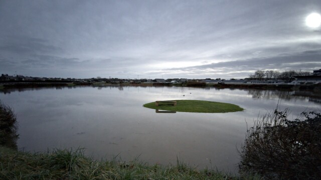
Where I walk the dog is one of the lowest points of the former marsh and is part of the flood defences of the town. The original river is now canalised in a concrete box and flows through the hippodrome, and if the water level is high then two patches either side of the pipe are designed to flood so that the town doesn't.
We've not had a lot of rain here in Saint-Malo, but further south in the department and the one below us there has been a lot of rain and some of the worst flooding in a century. As you can see the lake level here has risen about 2 metres above the level it normally has and filled in the whole basin with water, virtually everything in shot here is now about 1.5 metres deep in water - where it would normally be flat grass park space. This little island is just a small bump which has stayed dry.
The land here is very flat and another metre of water rise would have probably flooded the entire hippodrome, any more than that would have started to flood into adjoining properties. Some of them are brand new and stupidly have subterranean garages - which would have been completely flooded...
Comments
Sign in or get an account to comment.


