On High Water Head
I had this poorly thought out plan to get over to Great Langdale. Not to wander the biggies, because the forecast was for heavy rain and cloud above 500m. Rather it was to get up a tiddler, specifically Lingmoor Fell from where Wainwright had sketched the Pikes and Stickles and where they were likely to look their best. Trundling along we came to the hamlet of Elterwater and a place to park. So we took it. It's at moments like this that somehow or other the heart takes over and the brain takes a back seat. From the car park a path traced the course of the River Brathay, and instinctively, or perhaps simply attracted by it being there in all its wild and noisy loveliness, we followed the river. The river would east and brought us to Elter Water. Lingmoor was in the other direction. And from the water's edge, there it stood, reflected in the lake and topped with clouds.
Over the next half a mile or so a new plan must have been devised. I say 'must have' as if a plan from the get go is all important and not having one would have been unthinkable. But I can't be sure and if there was one, whatever it was was as fumbled as any earlier one. First though, we'd take a short detour of a few hundred yards to have a look at Skelwith Force. As we dossed about the rocks and the tumbling waters nothing planwise had been formulated as far as I can recall. Yet it was time we got to higher ground. I do remember I suggested we get up Park Fell and that quite how we should do that quickly became troublesome because we couldn't fix our position. Wandering can be helped by visual recognition of fell shapes so long as the clouds are up. I couldn't fathom how on earth we could be heading west as my compass clearly indicated. For that to be so we would have had to have done a U-turn. Plus the road was where I would expect it to be. Long story short, the path we'd taken and which seemed reasonably straight had over the passage of no more than a few hundred yards made a U-Turn.
With our position now clear we continued to Park House Farm where we availed ourselves of their strictly private drive to exit south for the A591. From here we walked along the curb east, past three properties to a gate and stile marking the entrance to Park Fell. Almost immediately we were met by the leader of a trio of mountain bikers who warned that many bikes were to follow. These were not leisurely riders. Each one seemed intent on cutting corners and leaping gazelle like from one tier to another, and from our higher vantage point observed their frantic application of brakes as unaware, the gate loomed into their view.
With the bikers now gone, I suggested, in one of those laxidazical moments, that we depart from the path and take the bee line route to what from the foot of the fell seemed the highest ground. This we did, picking out way via sheep runs, through the tall bracken, sphagnum and rocky outcrops, until eventually reaching a tall, drystone wall incorporating rock slabs conveniently placed to assist in stepping over, and a vertically stacked rock crest the better to hang from or pull on. Getting over, we continued upwards, only to appreciate the wall we had surmounted curved across the fell in such a way we would have to climb again.
It was after the second, fun but profitless wall climb, that we questioned the wisdom and purpose of whatever it was we were doing. It was raining hard, and visibility in the direction we were heading extended no further than the next larch. So we decided to give the summit a miss and find the path once more and take a wander south towards Tarn Hows. This course required a third traverse of the wall, achieved simply enough by our finding a place where it had been breached. From there we picked our way west/south-west, through the bog and bracken and tufts of orangey grasses, and in time, clambered a locked gate leading to a cattle byre. Just passed the byre we could pick out the yellow top of a signpost indicating the presence of the path. We had reached Arnside.
The journey from Arnside was uneventful. It was raining obviously and Phil and I remarked how, though our feet were dry, we could both feel the water sloshing in our boots. We entered Iron Keld, an aptly named wood of butchered conifers, some upright and stripped naked to their burned and blackened bark, others left to rot at the trackside. Such a sorry state, I imagined the sound of tanks rolling. From below Iron Keld the tarm came into view and we took a short path for a swifter descent to the waterside.
It was here that two important decisions had to be made. One was 'do we keep going south, knowing the car was about 4 miles to the north', and the other, 'if south, do we head for Hawkshead or Coniston'. There was no difference of opinion on both fronts. We should keep going south and we should head for Coniston, though a little further than Hawkshead. Our reasoning coincided in every particular. In reverse order [3] should be able to get a bus or taxi back, [2] should get good views of the lake, and [1] BlueBird XB.
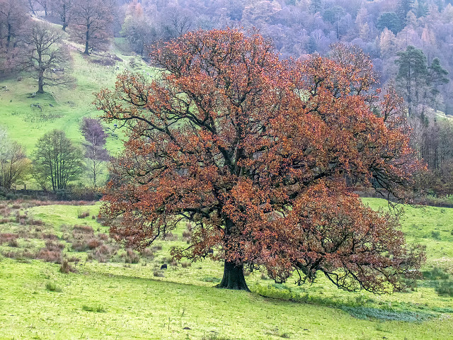
So Coniston it was, and for me, the wander south of Tarn Hows marked the best, most rewarding part of the day. We took the single track metalled road from Tarn Hows, but as soon as ever, took a path skirting Tarn Hows Wood, and on reaching the track serving Low Yewdale, crossed over into that open wooded area they call High Water Head. High Water Head is a great place to skip about. As its name suggests, it is positioned at the northern frontier of Coniston Water, and is a mini-fellside sloping down to the lake and the town. A provider of lengthways views of the lake, Grizedale Forest and the Furnace Fells on the eastern flank and the Old Man range to the west. It was here this old oak was photographed.
From here we descended through a wood of larches and other conifers unnamed on maps but for identification I call Yewdale Beck Wood, since it stands above that beck. The descent through the wood compels the wanderer to onward face the bracken and rock strata of Yew Pike's Long Crag tumbling into Coniston. Where the descent flattened out we watched a team in blue play a team in white, one of which would have been Coniston FC. I hope Coniston were in blue. The team in white were awful.
It wasn't long before we reached the famous bus shelter - the shelter with its very own website. There was no route from Coniston serving Elterwater, and we couldn't care less. It was now top of the list time, so we quickened our pace to the Black Bull.
Comments
Sign in or get an account to comment.


