
Creswick town to Ballarat
One of my favourite walks is the 24 kilometre/15 mile journey from the regional town of Creswick (located 129 kilometres/80 miles from Melbourne) to my favourite regional city of Ballarat (located as the Crow flies, southwards from Creswick). This rollicking trundle goes through the lower hills of the Great Dividing Range following a section of the Great Diving Range Trail (GDRT). The GDRT is a series of 4 interconnected tracks (I prefer Track as opposed to Trail) totalling 280 kilometres/174 miles that pass nearby, through and into many historic goldfields and Towns in central Victoria. These well defined tracks are suitable for both day walks and longer overnight or multi-day rambles. The four tracks are:
Wallaby Track: distance 92 kilometres/57 miles
Commences at the small town of Buninyong (south of Ballarat) beneath an extinct volcano that towers 719 metres/2,359 feet, and meanders into Ballarat before swinging away to the east through the Creswick forests into Creswick township. The track then continues on through further forests to end up at the spa resort town of Daylesford (113 kilometres/70 miles to the north-west of Melbourne). It was this section I completed (though in this case from Creswick to Ballarat).
Lerderderg Track: distance 80 kilometres/50 miles
Starts at the township of Bacchus Marsh and heads northward via the rugged and spectacularly beautiful Lerderderg Gorge State Park, passing Mount Blackwood 739 meters/2,425 feet (an extinct dome volcano) and Blackwood township, ending at Daylesford nestled at 616 metres/2,021 feet up in the Great Dividing Range. This is the Range that extends from the tip of Cape York Peninsular (northern Queensland) to Gariwerd (the Grampians) in western Victoria, a length of 3,500 kilometres/2,175 miles and the fourth longest unbroken Range in the world.
Dry Diggings Track: distance 55 kilometres/34 miles
The shortest of the four Tracks. Starts at Daylesford and runs via Hepburn Springs (another spa town), passing Mount Franklin (known by the Indigenous custodians as Lalgambook) at 635 metres/2,083 feet, another extinct breach volcano with a very distinctive crater and narrow breach where the present day access road enters. The track swings through more forests and a number of significant of gold mine diggings from yesteryear, eventually ending up at the large regional town of Castlemaine (located 119 kilometres/74 miles to the north of Melbourne).
Leanganook Track: distance 58 kilometres/36 miles
Arguably, the toughest of the Tracks. You set off from Castlemaine climbing up to Mount Alexander. At 744 metres/2,441 feet this mountain (known in the local Indigenous dialect as Lanjanuc) is one of the highest in the district with fabulous views, before following in part an old water race before arriving at Victoria's third largest regional city, Bendigo (131 kilometres/ 82 miles from Melbourne). Bendigo is a town built on gold and is rich in history since those initial gold rush days of the 1850s, along with Ballarat and Castlemaine.
Creswick sits at an altitude of around 430 metres/1,412 feet and has a population of over 3,000. Home to the Wemba-Wemba peoples of the Kulin nation who have enjoyed custodianship for well over 20,000 years and who retain strong links to the area despite the European usurpation, which commenced in the 1840s with the pioneer white settlers from the Creswick family (Henry, Charles and John) who, as Squatters, started a huge Sheep run. The town derived its name from this family. The town formally began amidst the Victorian gold rushes of the 1850s with the population peaking at an astonishing 25,000 at the height of the mad scramble for the golden lucre. Most of the 25,000 were hopefuls digging, panning and sluicing in the hills around the present day township, creating mayhem to the landscape. Sadly, Creswick has the infamy of being the location of Australia's worst below-ground gold mining disaster at the 'The New Australasian No.2 Deep Lead Gold Mine', to the north of Creswick. Near 5:00am on the morning of 12th December 1882, a shift of 29 Miners were trapped by rising flood waters that poured in from a breach through the nearby parallel No.1 shaft. Only 5 men survived by making it back to the Mine's surface despite frantic pumping efforts over 2 days. Poignantly, the trapped men scrawled last notes to their wives and family before they drowned. Some of these desperate notes can be read today and they are utterly wrenching in their sentiment. The men who died left behind widows and children that totalled 90.
In the early part of the twentieth century, a School of Forestry was established by the Government to train and equip young Foresters. Over time this morphed into a Campus run by the University of Melbourne and is set amidst plantations of Pines (which look so out of place) and a number of native Eucalypt stands. To get to Creswick is a dolly too, public transport wise, fortunately. A train journey to Ballarat of just over an hour then a connecting Bus of a further 20 minutes and you are there! Regular services operate 7 days a week, so it is ideal for day trips for plodders such as me.
The town nowadays is a typical modest sized country town. An assortment of facilities, including a rather pompous Town Hall, Pubs, Cafes, Stores, Churches, Schools and Health Centres. There is an understated War Memorial obelisk with a list of gold plated names of those who perished in the many wars that Australians have participated (willingly or otherwise). You will see such memorials in just about every Australian town. By instructive example: out of our then population of just over 5,000,000 in excess of 60,000 Australians perished in the First World War (plus at least triple that wounded) from a wholly volunteer Army, Navy and fledgling Air Force. Just about every family at that time in Australia was touched by the pitiless hand of that War's ruin.
There are a number of long standing homes and buildings in Creswick too, some of the oldest in Victoria. You would have no shortage of taking 'back in those days' photographs, with autumn especially a good time to snap away in this regard. There is a stolid brick Railway Station which closed in the 1980s and its buildings now look somewhat forlorn, though only today train services to the nearby town of Maryborough, to the north of Creswick and Ballarat, have recommenced after a twenty year hiatus. Something to travel on in the coming months.
Over many years I have slowly, (and slowly is the operative word), walked the entire length of the GDRT. These days I tend to stick to small short sections, such as the one from Creswick to Ballarat. I trundle along this particular section at least half a dozen times in year, with spring and summer generally being my favourite times. The forests here are lush with Eucalypts and a whole host of flora and fauna. There is a notable camp ground/picnic area at a place called Slaty Creek, about half way along the walk - it is a photo of Slaty Creek that I have as my screen saver. One of the most peaceful locations you could ever wish to visit with its occasionally flowing, though very shallow waterway (Slaty Creek) coloured rich with natural tannins. This spot is particularly attractive during and after rains as the whole forest, generally dry and thirsty, comes alive with the dynamic colours of the Australian Bush. The area has been extensively mined for gold as I have alluded to earlier. On the walk you will criss-cross a number of old shafts, water-races and mullock heaps, as a reminder of those backbreaking and tough days. The area is occasionally swept by fires too (good for the Eucalypts) and within weeks of such fires (which do not as rule kill the Eucalypts) you will see new growth and new seedlings on the burst - a wonderful, assuring sight in the Australian context that deeply moves my emotions.
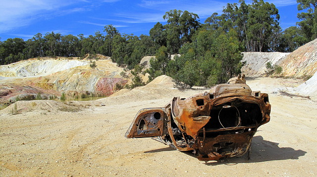
Yet, there is also extensive destruction in parts that offer this beauty a stark rebuke. One of these places is the old Creswick Quarry, about 4 kilometres/2 miles from Creswick. Long abandoned, this scar attracts trail bike riders and four-wheel drive enthusiasts, whose actions sculpt the Quarry walls, gullies and tracks even further. Over time, due to the erosive effects of this imposition many elements have been leeched from the soil providing a colourful, if not sobering, landscape. This is more evident after rain when the colours are even bolder as they leech away with the flowing water. Fine for photography but a stark reminder of the impact humans can have on the landscape. Sadly, the Quarry is also a dumping ground for a few old car wrecks, though cleanup efforts of recent times by Local Government Authorities are to be commended. On my walk through this part of the Quarry I came across and old smash-up that had been there for some time and is slowly rusting away. As you can see in the photograph, it had been upturned, which set against the Quarry and the deep cobalt of the winter sky, made for a curious image juxtaposition. Least I state, I was pleased to get back into the forest, where the landscape was more to my liking.
The whole area that the track between Creswick and Ballarat covers is full of interest and of natural wonders. You see both the glory of the forest (albeit much abused in the fairly recent yore) and the worst of human intervention (both present and past). Too, you see the fine rehabilitation works and many historical artefacts and sites, some preserved, some being slowly claimed by the earth. The walk is relatively easy, except for a few scrambly places, but it is a fine way to spend a day where your lungs are exhilarated by the fresh air and you body tingles under the dappled sunlight filtered by the lush eucalypts and assorted flora. At the end of the walk in lovely Ballarat you can indulge by downing a few ales to celebrate an effort well done before the curl up and nap train trip back to the suburban madness of Melbourne.
391
views
- 9
- 2
- Canon PowerShot G10
- f/4.0
- 6mm
- 80
Comments
Sign in or get an account to comment.


