
Granite n' Grass
A nice green landy blip today...not a trace of sea (!) well maybe just a little drop!
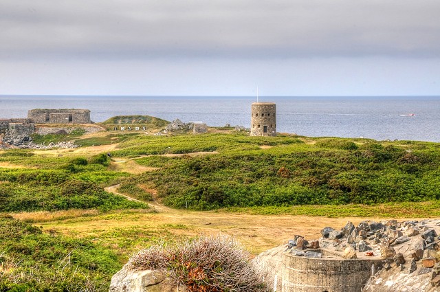
This is the view across L'Ancresse common looking north toward Fort Le Marchant: A fort that dates back to 1680. This was the largest fortification in northern Guernsey. This fort was used during the Napoleonic wars. Not sure why but according to the British Admiralty who produce marine charts, the fort is called Fort le Plomb...which is how it is marked on all Admiralty charts...but I am sure you already spotted this!
You can also see a Martello Tower built between August 1778 and March 1779 to deter possible French attacks after France had declared itself an ally of the American rebels in the American Revolutionary War. Towards the start of the Napoleonic Wars several towers received additional reinforcement in the form of batteries at their bases. A total of 15 such towers were built and today 12 towers still survive, three having been destroyed at different times. The tower shown is designated No4.
This area is also Guernsey's rifle range and between the fort and the tower you can probably make out the target numbers in front of the butts.
Downside for non shooters like us is that when active, this end of the common is out of bounds for safety.
This is where we lost Mr Casper last year when the gunfire frightened him! He ran off in the opposite direction and was not seen for 3 days...very worrying!
Hope you are enjoying Sunday!
8-)
190
views
- 6
- 1
- Nikon D300S
- 1/100
- f/20.0
- 68mm
- 400
Comments
Sign in or get an account to comment.


