
W-I-D-E on Wednesday: Travel
We've rather a lot of travel plans for the autumn, but the biggest trip (in several weeks' time) is to Canada again - mainly for another visit to Toronto to see our Canadian grandson & granddog again (plus our son & daughter-in-law of course!).
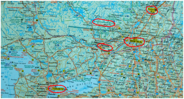
This time we've decided that while we're going that far we'll do a bit of travelling around prior to spending time in Toronto. So when we saw that Bobsblips's Widwed challenge is "travel", it seemed a good idea to blip a wide photo of a map showing our main calling points.
Problem: I thought we had a large flat map of the area - but we don't (memo to self: get one before we go!). So I had to dig out an old World Atlas - when (naturally) I discovered that the area in question was spread over 3 pages. Two were on facing pages so photographing them in one shot was fine (apart from a dividing line at the spine of the book - producing the roughly horizontal streak across the right part of the blip) but the other had to be photographed separately and merged with the others. This proved more tricky than I thought, and if you look too closely you'll see some faults at the interface. It was fun to challenge myself though!
I've ringed our main ports of call - we'll start in Montreal, drive to Quebec then double back to Ottawa stopping in Mount Tremblant National Park on the way. After Ottawa we'll go to Toronto to stay with the family.
I'm keeping the dates a secret at the moment so if you want to follow our little adverture you'll have to wait in suspense!
Comments
Sign in or get an account to comment.


